冷空气
Search documents
山东最低气温跌破0℃
Da Zhong Ri Bao· 2025-10-22 00:53
Core Viewpoint - The recent significant drop in temperatures across Shandong province is attributed to the influence of cold air masses, marking a shift from previous weather patterns characterized by persistent rainfall to a drier and colder climate [2][3]. Summary by Sections Current Weather Conditions - Shandong province has experienced a dramatic decline in temperatures, with the lowest recorded temperature at -0.2℃ on October 21, marking a new low for the second half of the year [2]. - The average temperature for October in Shandong is typically around 15.2℃, but current temperatures have fallen below this average, approaching the climate levels expected in November [2]. Causes of Temperature Drop - The primary reason for the ongoing low temperatures is the intensified cold air activity from Siberia, which has been able to penetrate the province due to the retreat of the subtropical high pressure [3]. - This cold air has not only caused a drop in temperatures but has also led to a shift from a "wet cold" to a "dry cold" climate, resulting in clearer skies as moisture is dispersed [3]. Short-term Weather Forecast - A gradual warming trend is expected from October 22 to 24, although the increase in temperatures will be slow [3]. - Following this brief warming period, a weak cold air mass is anticipated to bring light rain and a subsequent drop in temperatures around October 25 to 26 [3]. Long-term Weather Predictions - For November, the average temperature is projected to be between 7.5℃ and 8.5℃, slightly above the normal average of 7.5℃, with precipitation expected to be 20-50% lower than usual [4]. - The winter of 2025 is forecasted to have an average temperature of 1.0℃ to 2.0℃, which is also above the normal average of 0.6℃, with overall precipitation expected to be lower than average [4].
最强冷空气,发力了
Xin Lang Cai Jing· 2025-10-20 09:12
Core Viewpoint - A strong cold air mass is affecting China, leading to significant temperature drops across various regions, with the coldest temperatures of the second half of the year expected in the coming days [1][3]. Group 1: Temperature Changes - The cold air mass is causing temperatures in the central and eastern regions to drop by 4 to 8 degrees Celsius, with some areas experiencing drops exceeding 10 degrees Celsius [3][11]. - In northern cities like Beijing, temperatures have reached new lows for the year, with the minimum temperature recorded at -0.5 degrees Celsius [3][5]. - The lowest temperature line is expected to move southward to northern parts of Shaanxi and eastern Gansu, indicating a significant shift in weather patterns [11][13]. Group 2: Impact of Typhoon "Fengshen" - Typhoon "Fengshen" is contributing to the temperature fluctuations in eastern and southern China, although it is not making landfall [7][9]. - The typhoon is enhancing wind strength in eastern and southern sea areas, with wind speeds reaching 11-12 levels, causing temperature drops of 6 to 10 degrees Celsius across Guangdong and other regions [9][11]. Group 3: Public Advisory - Due to the drastic temperature changes, the public is advised to dress warmly and take precautions against the cold [18].


较强冷空气继续影响我国中东部 “风神”将给南海北部带来强风雨
Yang Guang Wang· 2025-10-20 03:12
Group 1 - A strong cold air mass is affecting China, leading to lower temperatures across the country, with the minimum temperature line expected to drop to central and northern Shaanxi and eastern Gansu [1] - The Central Meteorological Observatory forecasts a temperature drop of 4 to 6 degrees Celsius in central and eastern regions, with some areas in southern Jiangnan, southern China, and southern Guizhou experiencing drops of around 8 degrees Celsius [1] - Typhoon "Fengshen" is also impacting the coastal areas of southern China, bringing wind and rain [2] Group 2 - As of October 19, 55 passenger ferry routes and 120 passenger ferries in the Fujian coastal area have been suspended due to the weather conditions [2] - The Qiongzhou Strait passenger roll-on/roll-off transport will be suspended from October 20 to 23, affecting travel plans [2] - Some train services to and from Hainan will also be suspended from October 20 to 22 due to the typhoon [2]
受冷空气影响 上海昨日入秋
Jie Fang Ri Bao· 2025-10-20 01:37
从昨天开始,今年下半年以来最强冷空气继续影响我国中东部,上海显著降温。昨天白天,中心城 区(徐家汇站)温度跌至19.3℃。受冷空气补充影响,今天,上海风力增大,气温继续下跌,全天在 17℃至19℃。大风天气会持续到周三前后。 与此同时,上海今年夏季又创纪录。从5月12日入夏至10月18日,上海已经度过了160个夏天,位居 史上第二长。 记者 戚颖璞 上海的夏天终于结束了。上海中心气象台表示,申城已于昨天正式入秋。 ...
北方大部气温低迷 台风“风神”进入南海
Zhong Guo Xin Wen Wang· 2025-10-20 01:22
Group 1 - The core viewpoint of the article highlights the impact of cold air on northern China, with temperatures dropping significantly, reaching a low of -0.5℃ in Beijing's southern suburbs, marking the lowest temperature of the second half of the year [1] - The article mentions that the cold air will continue to affect the central and eastern regions, with temperature drops of 4-6℃ in areas such as Jianghuai, Jianghan, and southern Jiangnan, and some regions experiencing drops of around 8℃ [3] - A yellow wind warning has been issued by the Central Meteorological Observatory, predicting winds of 5-6 levels in various northern and eastern regions, with gusts reaching 7-8 levels in certain areas [5] Group 2 - The article indicates that the southern regions will continue to experience overcast and rainy weather, with some areas in Xinjiang, Tibet, and other regions seeing light to moderate snow or sleet, while central and southwestern Hubei, eastern Sichuan, and parts of Taiwan may experience heavy rain or even torrential rain [6] - Meteorological experts warn of persistent strong winds in the eastern and southern sea areas over the next three days, advising operational platforms and vessels to prepare for the winds and coastal residents to stay away from temporary structures [8]
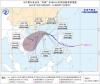
“风神”叠加冷空气 将给海南岛带来强风雨及明显降温
Zhong Guo Xin Wen Wang· 2025-10-19 07:02
来源:中国新闻网 "风神"叠加冷空气 将给海南岛带来强风雨及明显降温 编辑:熊思怡 中新网海口10月19日电 (许嘉 李凡 吴春娃)海南省气象台19日发布预报称,受今年第24号台风"风神"和 南下冷空气共同影响,海南岛多地将出现较强风雨天气,气温明显下降。 广告等商务合作,请点击这里 据监测,"风神"(热带风暴级)19日08时其中心位于北纬14.0度、东经121.4度,也就是在菲律宾吕宋岛 上,中心附近最大风力8级(20米/秒),七级风圈半径150~180公里。 气象部门预计,"风神"将以每小时30~35公里的速度向西北方向移动,今天傍晚前后进入南海东部海 面,强度逐渐加强,最强可达强热带风暴级或台风级(30~35米/秒,11~12级);21日白天开始受南下冷 空气影响,在南海北部海面转向西南方向移动,向海南岛东南部海面靠近,强度逐渐减弱。 海南省气象台预计,受"风神"和冷空气共同影响,19日夜间~23日南海中部、北部海面和海南省大部分 海域自东向西将有强风雨天气。 21日~23日,海南岛东半部地区有大到暴雨、局地大暴雨,西半部地区有中到大雨;全岛最高气温从19 日的29~32℃下降至21~25℃;最低气温从 ...
北方冷意加深南方频刷气温新低 台风“风神”将影响华南沿海
Yang Shi Wang· 2025-10-19 01:11
西南等地阴雨持续 台风"风神"靠近华南沿海风雨渐增 昨天,随着冷空气南下,主雨带南压、减弱,西南到江淮、江南等地出现降雨,云南等地部分地区雨势 较强。监测显示,浙江中南部、江西北部、湖北东南部、湖南南部、贵州西部和东北部、云南中部和东 北部、四川南部等地出现分散性大雨或暴雨,四川攀枝花等局地大暴雨。 今明两天,西南地区东部、西北地区东南部、黄淮西部、江淮等地还会有阴雨天气,以小到中雨为主, 西藏东部、青海南部等地将有小到中雪或雨夹雪。 此外,随着今年第24号台风"风神"逐渐靠近,未来几天台湾、福建、广东等地降雨将会陆续增多。"风 神"将以每小时30-35公里的速度向西北方向移动,今天傍晚前后进入南海东部海面,强度逐渐加强,最 强可达强热带风暴级或台风级。 具体来看,中央气象台预计,今天,内蒙古东北部、黑龙江西南部、西藏中部和东部、青海南部和西 部、甘肃西南部、川西高原北部等地部分地区有小到中雪或雨夹雪,其中,青海南部、川西高原北部等 地部分地区有大到暴雪。甘肃南部、陕西中南部、四川东北部和南部、云南西部和北部、台湾岛等地部 分地区有中到大雨,其中,台湾岛中北部等地部分地区有暴雨或大暴雨。 央视网消息:据中国天 ...

北方持续偏冷南方即将迎降温 华西阴雨仍频繁
Yang Shi Wang· 2025-10-18 01:23
央视网消息:据中国天气网消息,近日,今年下半年来最强冷空气的影响已逐渐展开,今天(10月18 日)起将影响南方地区。预计未来几天,南方地区将陆续迎降温,多地气温或创立秋后新低,而北方气 温会持续偏低,公众需注意添衣保暖。 后天,新疆沿天山地区、青海东南部、川西高原北部等地部分地区有小雪或雨夹雪。陕西中部、河南西 部、湖北南部、湖南西北部、四川南部、云南东北部、福建东南部、广东东南部、台湾岛等地部分地区 有中到大雨,其中,广东东南部沿海等地部分地区有暴雨。 近期,华西多地降雨频繁,四川盆地等地部分地区累计雨量较大,地质灾害风险较高,需谨慎前往山 区、河道等灾害高风险地区,驾车请远离低洼路段和山区道路。 北方气温将持续偏低 南方今起降温陆续展开 昨天,华北、黄淮受冷空气影响出现明显降温。监测显示,昨天14时,内蒙古中部、河北西北部一带降 温幅度最大,部分地区较昨天同时次降温12至18℃,张北等地气温降至零下。 未来几天,较强冷空气还将持续影响中东部地区,过程最低气温0℃线将南压到华北北部至陕西北部、 甘肃东部一带,大部地区将出现今年下半年以来气温新低,并且由于冷空气源源不断补充,北方气温将 难以回升,预计10月2 ...

我省正式进入气象意义上的冬季
Liao Ning Ri Bao· 2025-10-18 00:33
Core Points - The province officially entered meteorological winter on October 17, three days earlier than the average date in previous years [1] - The start of winter is defined as the first day when the average daily temperature remains below 10°C for five consecutive days [1] - The province is currently experiencing significant temperature drops due to the strongest cold air mass of the year, with maximum temperatures falling to around 10°C [1] - Some areas, including Fushun, Benxi, and Tieling, are expected to see light snow [1] - The cold air mass is projected to reach its peak between October 19 and October 20, with minimum temperatures dropping below freezing, marking the lowest temperatures since the beginning of the second half of the year [1] - Meteorological experts indicate that an early onset of winter does not necessarily correlate with a cold winter, as there is no inherent connection between the two [1]