台风
Search documents
11月3日—4日,海南岛东、中部局地有大暴雨到特大暴雨
Zhong Guo Xin Wen Wang· 2025-11-03 06:53
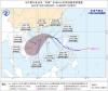
Core Viewpoint - Hainan Island is expected to experience heavy to extremely heavy rainfall from November 3 to 4, influenced by an easterly airflow, with significant impacts anticipated from Typhoon "Haikui" [1][2] Weather Forecast - From November 3 to 4, areas in eastern and central Hainan Island are forecasted to receive heavy to extremely heavy rainfall, while other regions will experience moderate to heavy rain [1] - The weather monitoring indicates that a new round of widespread rainfall began on November 2, with coastal areas around Hainan Island experiencing gusts of wind exceeding 7 levels [1] Typhoon "Haikui" Details - Typhoon "Haikui," classified as a strong tropical storm, was located at latitude 10.8°N and longitude 128.8°E on November 3, with maximum wind speeds of 11 levels (30 m/s) near its center [1] - The typhoon is expected to move westward at approximately 20 km/h, passing through the central Philippines on November 4 and entering the southeastern South China Sea on November 5, with its intensity gradually increasing to a strong typhoon level (42-50 m/s, 14-15 levels) [1] Impact on Maritime Operations - From November 5 to 7, the South China Sea's central and southern regions are expected to experience wind speeds of 9-12 levels and gusts of 13-15 levels due to Typhoon "Haikui," with strong wind and rain conditions affecting the Nansha, Zhongsha, and Xisha Islands [2] - Hainan's meteorological department has advised local authorities to monitor rainfall accumulation and manage safety measures for reservoirs and geological disaster risk points [2]
南方地区降雨减弱 较强冷空气将自西向东影响我国
Zhong Guo Xin Wen Wang· 2025-11-03 02:48
Summary of Key Points Core Viewpoint - The article discusses the weather conditions in China, highlighting the weakening of rainfall in the southern regions and the impending arrival of a strong cold air mass from the west, which will affect various parts of the country starting November 5 [1][6]. Weather Conditions - Rainfall is currently concentrated in the southwestern to Jiangnan and southern China regions, with expected moderate to heavy rain in areas such as central and western Yunnan, central and southern Guizhou, southern Hunan, southern Jiangxi, eastern Guangxi, western Guangdong, and southeastern Hainan [2][6]. - The rainfall is predicted to significantly decrease in the aforementioned areas starting tomorrow [2]. Cold Air Mass Impact - A strong cold air mass is forecasted to move from west to east across China from November 5 to 9, initially impacting regions like Xinjiang, western Qinghai-Tibet Plateau, and western Inner Mongolia, leading to temperature drops of 6 to 8 degrees Celsius, with some areas experiencing drops of 10 to 16 degrees Celsius [9]. - Accompanying this cold air mass, there will be winds of 4 to 6 levels, with mountain passes experiencing winds of 8 to 9 levels and gusts reaching 10 to 11 levels [9]. Snowfall and Weather Warnings - The cold air mass will bring light to moderate snow or sleet in northern Xinjiang, with high-altitude areas expecting heavy to extreme snowfall, adding 8 to 12 centimeters of snow, and locally up to 15 to 22 centimeters [9]. - Public advisories are issued to monitor weather forecasts and prepare accordingly for the changing conditions [9].


雾和霾反复来扰!下周中后期较强冷空气登场 南方仍将阴雨频繁
Yang Shi Wang· 2025-11-01 12:06
Summary of Key Points Core Viewpoint - The article discusses the recent weather conditions in China, particularly focusing on the occurrence of dense fog in several regions, the expected changes in weather patterns, and the implications for air quality and temperature fluctuations. Group 1: Weather Conditions - Multiple regions including Beijing, Tianjin, Hebei, Henan, Shandong, Jiangsu, Anhui, and Hubei experienced dense fog, with visibility dropping below 50 meters in areas like Tongzhou, Dezhou, Shangqiu, Bengbu, and Huainan [1][3] - A red alert for fog was issued in Julu County, Hebei, indicating severe visibility issues [3] Group 2: Future Weather Predictions - Following the fog, the weather is expected to improve due to sunlight and weak cold air, with no significant smog forecasted for the next few days [3] - However, from November 4 to 7, the air quality in North China and the Huanghuai region is predicted to deteriorate again, leading to the return of fog and haze [5] Group 3: Temperature Trends - The temperature in central and southern North China is currently around or above 20°C, marking a recent high [8] - A significant drop in temperature is anticipated next week due to a strong cold air mass, with expected decreases of 4 to 8°C in many areas, and localized drops exceeding 10°C [8] Group 4: Rainfall and Flood Risks - From November 2 to 4, heavy rainfall is expected in the eastern Southwest, central and southern Jiangnan, eastern Guangxi, western Guangdong, and Hainan, with cumulative precipitation reaching 30 to 80 millimeters, and localized areas in Yunnan and Hainan potentially exceeding 200 millimeters [9][13] - The rainfall may lead to significant flooding risks in certain regions, particularly in Yunnan and southern Sichuan, where the rainfall could surpass the total for the entire month of October [13] Group 5: Tropical Weather Developments - The Japan Meteorological Agency has classified a tropical disturbance east of the Philippines as a tropical depression, which is expected to develop into Typhoon "Haigui" by November 5, with potential impacts on the South China Sea [14]

最强冷空气,发力了
Xin Lang Cai Jing· 2025-10-20 09:12
Core Viewpoint - A strong cold air mass is affecting China, leading to significant temperature drops across various regions, with the coldest temperatures of the second half of the year expected in the coming days [1][3]. Group 1: Temperature Changes - The cold air mass is causing temperatures in the central and eastern regions to drop by 4 to 8 degrees Celsius, with some areas experiencing drops exceeding 10 degrees Celsius [3][11]. - In northern cities like Beijing, temperatures have reached new lows for the year, with the minimum temperature recorded at -0.5 degrees Celsius [3][5]. - The lowest temperature line is expected to move southward to northern parts of Shaanxi and eastern Gansu, indicating a significant shift in weather patterns [11][13]. Group 2: Impact of Typhoon "Fengshen" - Typhoon "Fengshen" is contributing to the temperature fluctuations in eastern and southern China, although it is not making landfall [7][9]. - The typhoon is enhancing wind strength in eastern and southern sea areas, with wind speeds reaching 11-12 levels, causing temperature drops of 6 to 10 degrees Celsius across Guangdong and other regions [9][11]. Group 3: Public Advisory - Due to the drastic temperature changes, the public is advised to dress warmly and take precautions against the cold [18].

较强冷空气继续影响我国中东部 “风神”将给南海北部带来强风雨
Yang Guang Wang· 2025-10-20 03:12
Group 1 - A strong cold air mass is affecting China, leading to lower temperatures across the country, with the minimum temperature line expected to drop to central and northern Shaanxi and eastern Gansu [1] - The Central Meteorological Observatory forecasts a temperature drop of 4 to 6 degrees Celsius in central and eastern regions, with some areas in southern Jiangnan, southern China, and southern Guizhou experiencing drops of around 8 degrees Celsius [1] - Typhoon "Fengshen" is also impacting the coastal areas of southern China, bringing wind and rain [2] Group 2 - As of October 19, 55 passenger ferry routes and 120 passenger ferries in the Fujian coastal area have been suspended due to the weather conditions [2] - The Qiongzhou Strait passenger roll-on/roll-off transport will be suspended from October 20 to 23, affecting travel plans [2] - Some train services to and from Hainan will also be suspended from October 20 to 22 due to the typhoon [2]
北方大部气温低迷 台风“风神”进入南海
Zhong Guo Xin Wen Wang· 2025-10-20 01:22
Group 1 - The core viewpoint of the article highlights the impact of cold air on northern China, with temperatures dropping significantly, reaching a low of -0.5℃ in Beijing's southern suburbs, marking the lowest temperature of the second half of the year [1] - The article mentions that the cold air will continue to affect the central and eastern regions, with temperature drops of 4-6℃ in areas such as Jianghuai, Jianghan, and southern Jiangnan, and some regions experiencing drops of around 8℃ [3] - A yellow wind warning has been issued by the Central Meteorological Observatory, predicting winds of 5-6 levels in various northern and eastern regions, with gusts reaching 7-8 levels in certain areas [5] Group 2 - The article indicates that the southern regions will continue to experience overcast and rainy weather, with some areas in Xinjiang, Tibet, and other regions seeing light to moderate snow or sleet, while central and southwestern Hubei, eastern Sichuan, and parts of Taiwan may experience heavy rain or even torrential rain [6] - Meteorological experts warn of persistent strong winds in the eastern and southern sea areas over the next three days, advising operational platforms and vessels to prepare for the winds and coastal residents to stay away from temporary structures [8]
琼州海峡,将短暂停运
券商中国· 2025-10-19 12:47
Group 1 - The 24th typhoon "Fengshen" is moving northwest at a speed of approximately 35 kilometers per hour and has entered the South China Sea, potentially reaching strong tropical storm or typhoon level (30-35 m/s, level 11-12) [1] - The Qiongzhou Strait passenger and roll-on/roll-off transport will cease operations on October 20 at 14:00, with expected impact lasting until the morning of October 23 [2] - Haikou's transportation and port management authority announced that Haikou New Port, Xiuying Port, and Railway South Port will stop operations starting from October 20 at 14:00, advising passengers to arrive at least 1 to 2 hours early for ticket inspection [2]

“风神”叠加冷空气 将给海南岛带来强风雨及明显降温
Zhong Guo Xin Wen Wang· 2025-10-19 07:02
来源:中国新闻网 "风神"叠加冷空气 将给海南岛带来强风雨及明显降温 编辑:熊思怡 中新网海口10月19日电 (许嘉 李凡 吴春娃)海南省气象台19日发布预报称,受今年第24号台风"风神"和 南下冷空气共同影响,海南岛多地将出现较强风雨天气,气温明显下降。 广告等商务合作,请点击这里 据监测,"风神"(热带风暴级)19日08时其中心位于北纬14.0度、东经121.4度,也就是在菲律宾吕宋岛 上,中心附近最大风力8级(20米/秒),七级风圈半径150~180公里。 气象部门预计,"风神"将以每小时30~35公里的速度向西北方向移动,今天傍晚前后进入南海东部海 面,强度逐渐加强,最强可达强热带风暴级或台风级(30~35米/秒,11~12级);21日白天开始受南下冷 空气影响,在南海北部海面转向西南方向移动,向海南岛东南部海面靠近,强度逐渐减弱。 海南省气象台预计,受"风神"和冷空气共同影响,19日夜间~23日南海中部、北部海面和海南省大部分 海域自东向西将有强风雨天气。 21日~23日,海南岛东半部地区有大到暴雨、局地大暴雨,西半部地区有中到大雨;全岛最高气温从19 日的29~32℃下降至21~25℃;最低气温从 ...
北方冷意加深南方频刷气温新低 台风“风神”将影响华南沿海
Yang Shi Wang· 2025-10-19 01:11
西南等地阴雨持续 台风"风神"靠近华南沿海风雨渐增 昨天,随着冷空气南下,主雨带南压、减弱,西南到江淮、江南等地出现降雨,云南等地部分地区雨势 较强。监测显示,浙江中南部、江西北部、湖北东南部、湖南南部、贵州西部和东北部、云南中部和东 北部、四川南部等地出现分散性大雨或暴雨,四川攀枝花等局地大暴雨。 今明两天,西南地区东部、西北地区东南部、黄淮西部、江淮等地还会有阴雨天气,以小到中雨为主, 西藏东部、青海南部等地将有小到中雪或雨夹雪。 此外,随着今年第24号台风"风神"逐渐靠近,未来几天台湾、福建、广东等地降雨将会陆续增多。"风 神"将以每小时30-35公里的速度向西北方向移动,今天傍晚前后进入南海东部海面,强度逐渐加强,最 强可达强热带风暴级或台风级。 具体来看,中央气象台预计,今天,内蒙古东北部、黑龙江西南部、西藏中部和东部、青海南部和西 部、甘肃西南部、川西高原北部等地部分地区有小到中雪或雨夹雪,其中,青海南部、川西高原北部等 地部分地区有大到暴雪。甘肃南部、陕西中南部、四川东北部和南部、云南西部和北部、台湾岛等地部 分地区有中到大雨,其中,台湾岛中北部等地部分地区有暴雨或大暴雨。 央视网消息:据中国天 ...

副热带高压给西安城墙送来“限定皮肤”,专家解读背后原因
Yang Shi Xin Wen· 2025-10-16 02:04
Core Points - Continuous rainy weather in Shaanxi Province since September has led to the growth of moss on sections of the Xi'an City Wall, particularly between Yongning Gate and Wenchang Gate, attracting public attention [1] - Experts indicate that the moss is only growing on the surface of the wall and does not penetrate deeply, thus not damaging the structural integrity of the wall [3] - The local meteorological department reported that the cumulative rainfall in many areas of Shaanxi has reached historical highs for this period, with six regional heavy rain events recorded, ranking second since 1961 [7] Weather Conditions - The persistent rainy weather is attributed to the stable presence of the subtropical high pressure in the Huaxi-Huanghuai region, with Shaanxi located in a warm and humid airflow zone, combined with multiple short-wave troughs from the westerly wind belt [5] - The local meteorological department forecasts intermittent rainfall in most of Shaanxi on the 15th, with a return to rain on the 16th and 17th, but a significant reduction in rainfall intensity is expected after the 20th [9]
