气温下降
Search documents
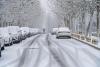
雨雪、大风已经在路上!气温断崖下跌!湖北将迎最冷“四九”
Xin Lang Cai Jing· 2026-01-14 02:01
Core Viewpoint - The weather forecast indicates a significant temperature shift in China, with a strong cold air mass expected to impact most regions, leading to a drop in temperatures after a period of unseasonably warm weather [1]. Group 1: Temperature Changes - The highest temperature of 15°C is expected to extend northward to southern Hebei, while the 20°C line will rise to southern Henan and central Jiangsu [1]. - Most areas from the northwest to South China will experience above-normal temperatures, particularly in the Huanghuai to Jiangnan regions, where the maximum temperature may exceed 10°C above normal [1]. - A strong cold air mass is forecasted to affect most of the country starting this weekend, with northeastern regions experiencing temperatures dropping below -30°C [1]. Group 2: Regional Weather Forecast - In Hubei, the weather will remain sunny and warm for the next three days, with maximum temperatures reaching 24°C on January 14 and similar temperatures on January 15, making it a good time for outdoor activities [1]. - A significant weather change is expected around January 19, with widespread rain, snow, strong winds, and a sharp temperature drop anticipated, with average temperature declines of 6-10°C [1]. - The forecast indicates that the weather pattern of less rain and snow in central and eastern regions will change, potentially leading to widespread precipitation [1].


明天进“三九”!北京周五山区零星飘雪,大风降温紧随
Bei Jing Ri Bao Ke Hu Duan· 2026-01-07 04:31
Weather Forecast - The weather in Beijing is expected to be mostly cloudy with sunny intervals on January 7, with a maximum temperature of 4℃ in the plains and 0-3℃ in mountainous areas [7] - Nighttime temperatures on January 7 are forecasted to drop to -7℃ in the plains and -12 to -10℃ in mountainous regions [7] - On January 8, the daytime will be sunny with maximum temperatures of 5℃ in the plains and 2-4℃ in mountainous areas [8] - January 9 will see cloudy weather with possible light snow in mountainous areas, and maximum temperatures of 7℃ in the plains and 4-6℃ in mountainous regions [9] Temperature Trends - The highest temperature recorded on January 6 was 7.7℃, while the lowest was -2℃ [5][6] - The upcoming week will experience a significant drop in temperatures, especially at night, with warnings to dress warmly [12] - The overall trend indicates a dry weather pattern across most of the country, with significant temperature fluctuations, particularly in the Jiangnan and South China regions [14]

吉林多条高速公路因降雪关闭 部分航班延误
Zhong Guo Xin Wen Wang· 2025-12-23 07:21
Core Viewpoint - Jilin Province is experiencing significant snowfall, leading to the closure of multiple highways and delays in flights, with a notable impact on transportation and weather conditions in the region [1][2][4]. Group 1: Weather Impact - Jilin Province has seen a substantial snowfall event, classified as heavy snow, with the snowfall beginning early on December 23 and affecting areas from west to east [2]. - The snowfall has resulted in over 200 highway entrances being closed or restricted across the province by 1 PM [2]. - The weather system is expected to move quickly, with the snowfall likely ending by the night of December 23 to the early morning of December 24 [4]. Group 2: Transportation Disruptions - By 11 AM on December 23, 16 flights at Changchun Longjia International Airport were either canceled or delayed due to the snowfall [4]. - The airport has upgraded its snow removal emergency plan to a yellow alert level to ensure flight safety [4]. Group 3: Temperature Changes - Following the snowfall, Jilin Province is anticipated to experience a significant drop in temperature, with a cumulative decrease of 10°C to 14°C, and localized areas in the east potentially reaching lows of -30°C to -28°C by the early morning of December 26 [4]. - The average precipitation in Jilin Province from November 1 to December 15 was 15.7 mm, which is 37% less than the average for the same period, marking it as one of the driest winters since 2000 [4].

两股冷空气先后影响中东部地区 部分地区降温达10℃
Zhong Guo Xin Wen Wang· 2025-12-21 01:46
Summary of Key Points Core Viewpoint - The article discusses the impact of two cold air masses affecting the central and eastern regions of China, leading to significant temperature drops and snowfall in various areas, with potential implications for energy supply, public health, agriculture, and transportation safety. Group 1: Weather Conditions - Snowfall was reported in regions such as northern and western Xinjiang, central Gansu, northeastern Qinghai, northeastern Inner Mongolia, and northern Heilongjiang, with some areas experiencing moderate to heavy snow [2][6] - A temperature drop of 6 to 10°C was observed in eastern Inner Mongolia, western Inner Mongolia, northeastern regions, North China, and the middle and lower reaches of the Yangtze River, with local drops exceeding 14°C [3][4] - The cold air mass is expected to bring further temperature decreases of 4 to 6°C across most areas north of the Yangtze River, with local drops exceeding 10°C in northeastern regions [4][5] Group 2: Wind Conditions - Wind speeds of 5 to 6 levels were recorded in regions such as central and eastern Inner Mongolia, northern Xinjiang, and parts of Tibet and Qinghai, with gusts reaching 6 to 8 levels [5][7] - Coastal areas including the Yellow Sea, East China Sea, and Taiwan Strait are expected to experience strong winds of 7 to 8 levels, with gusts up to 10 to 11 levels, particularly in the Taiwan Strait [5] Group 3: Future Weather Forecast - From December 22 to 25, another cold air mass will affect China, leading to further temperature drops and precipitation, including snow and rain in various regions [4][9] - Specific forecasts indicate that areas in southern Xinjiang, Gansu, northern Shaanxi, and northeastern regions will see light to moderate snow or sleet, with local heavy snow [9][11]

北京今天气温下降西部北部有降雪 明天继续降温最高温跌至冰点
Yang Shi Wang· 2025-11-30 23:43
Summary of Key Points Core Viewpoint - Beijing is experiencing a significant drop in temperature, with forecasts indicating continued cold weather and potential snowfall in certain areas [1][2]. Weather Forecast - Today, Beijing's weather is expected to transition from sunny to overcast, with light snow possible in the western and northern regions. The maximum temperature will reach 4°C, while the minimum will drop to -7°C [1][2]. - Tomorrow, the weather will primarily be sunny, but temperatures will further decrease, with a maximum of 0°C and a minimum of -8°C. Wind conditions will also intensify, with gusts reaching up to 6 levels [2]. Wind and Cold Alerts - A cold wave blue alert has been issued, advising the public to take precautions against the cold and to be cautious of travel conditions due to potential snowfall in the western and northern areas [2].

尼泊尔加德满都气温骤降 空气污染同步加剧
Zhong Guo Xin Wen Wang· 2025-11-27 23:21
Core Points - The temperature in Kathmandu, Nepal has significantly dropped, with the minimum temperature recorded at 7.4 degrees Celsius, a decrease of 3 degrees from the previous week [1] - The air quality in Kathmandu has worsened due to increased consumption of heating fuels and the burning of leaves and crop residues, leading to a rise in air pollution [2] Group 1 - The recent cold wave is linked to seasonal changes, with expectations of further drops in temperature during early mornings and evenings [1] - Kathmandu's maximum temperature was recorded at 19.2 degrees Celsius, lower than the previous week's 20.2 degrees Celsius [1] - The air quality index (AQI) in Kathmandu exceeded 100, indicating poor air quality [2] Group 2 - Environmental experts noted that the lack of winter rainfall and reduced wind speeds hinder the dispersion of smoke and dust in the valley [4] - Kathmandu frequently ranks among the cities with the worst air pollution during this time of year due to various factors including vehicle emissions, road dust, and industrial discharges [4]

北京发布大风黄色预警 山区局地阵风可达10级以上
Xin Hua She· 2025-11-23 12:38
Core Points - Beijing Meteorological Bureau issued a yellow wind warning for November 24, predicting a north wind of around level 4 and gusts up to level 8, with some mountainous areas exceeding level 10 [1] - A significant drop in temperature is expected due to strong cold air, with nighttime lows reaching -3 degrees Celsius on November 24 and daytime highs dropping to single digits on November 25 [1] - Rain mixed with snow or snow is anticipated in mountainous areas on the morning to noon of November 24, while light snow is possible in some plain areas [1] Weather Impact - The wind is expected to peak from noon to evening on November 24, necessitating precautions against strong winds and potential falling objects [1] - The temperature drop combined with wind chill will create a very cold sensation, prompting the need for warm clothing and precautions during outdoor activities [1] - The upcoming week will see multiple windy days in Beijing, emphasizing the importance of staying away from temporary structures and being cautious of high-altitude falling objects [1] Safety Recommendations - Residents are advised to take measures against the cold, including proper hydration and fire safety, especially regarding heating equipment to prevent fire hazards [1]
冷空气,又来了……
Qi Lu Wan Bao· 2025-10-25 10:01
Core Points - A new cold air mass is affecting northern China, leading to significant temperature drops and snowfall in various regions [6][1] - The temperature in many northern areas is expected to reach new lows, with some places dropping below freezing for the first time this season [6][1] - Continuous snowfall is anticipated in the eastern part of the Tibetan Plateau, with heavy snow expected in Inner Mongolia and Heilongjiang [2][4] Summary by Sections Weather Impact - The cold air mass will cause temperatures to drop by 4°C to 6°C in northern regions, with some areas experiencing drops of over 8°C [6] - Cities like Changchun and Shenyang are expected to set new low temperatures since autumn began, with Taiyuan dropping to freezing and Xining below zero [6][1] Snowfall Forecast - Continuous snowfall is forecasted for the eastern Tibetan Plateau, with moderate to heavy snow expected in parts of Inner Mongolia and Heilongjiang [2][4] - Areas such as Qinghai and Gansu will see varying snowfall, with some regions experiencing blizzards [4][5] Agricultural and Transportation Concerns - The meteorological department warns of the impact of ongoing snowfall on agricultural facilities, livestock, and transportation safety in affected regions [5]
秋冬之际 邂逅五彩诗意画卷 新疆巴州 克尔古提:鹿鸣河谷 秋色正斑斓
Yang Shi Wang· 2025-10-20 12:47
Group 1 - The article discusses a significant temperature drop in various regions, including a decrease of 4 to 6 degrees Celsius in the southeastern part of the northwest region and central northern China [1]

冷空气持续影响 15个城市继续刷新下半年最低气温纪录
Yang Shi Xin Wen Ke Hu Duan· 2025-10-20 08:05
Core Points - A cold air mass is moving east and south, affecting a large area in central and eastern China, with temperatures in the north remaining low and southern regions experiencing new lows for the second half of the year [1][2]. Group 1: Temperature Records - 15 cities, including Harbin, Changchun, Wuhan, and Shanghai, have recorded their lowest temperatures of the second half of the year, with Shenyang and Yinchuan dropping below 0°C for the first time this autumn [2]. - The temperature in central and eastern regions is expected to drop further by 4 to 8°C, with some areas experiencing a decrease of up to 10°C [2]. Group 2: Northern Region Conditions - Most northern areas will maintain low temperatures, with maximum temperatures in places like Inner Mongolia and Northeast China only reaching single digits, and the 0°C line extending to Shaanxi and Gansu [3]. - Current temperatures in the north are significantly lower than the historical averages for this time of year, with maximum temperatures being 8 to 10°C lower than usual, resembling conditions typical of November [3]. Group 3: Southern Region Outlook - Southern cities, including Nanjing and Hefei, are also experiencing their lowest temperatures of the second half of the year, with maximum temperatures below 15°C [4]. - From the 22nd, temperatures in regions like Zhejiang and Shanghai are expected to gradually rise back to seasonal averages [4]. Group 4: Precipitation Conditions - Most of the country will see weak precipitation over the next couple of days, but the Sichuan and Shaanxi regions will continue to experience persistent rain [5]. - The Central Meteorological Observatory forecasts moderate to heavy rain in parts of Shaanxi, Hubei, and Sichuan, advising the public to be cautious of slippery roads and potential secondary disasters [5].